

You can find on this page the Lisbon streets map to print and to download in PDF. The Lisbon roads map presents the road network, main roads, routes and motorways of Lisbon in Portugal.

The Lisbon streets map shows all street network and main roads of Lisbon. This streets map of Lisbon will allow you to find your routes through the streets of Lisbon in Portugal. The Lisbon streets map is downloadable in PDF, printable and free.
Rua Augusta is a very famous street in Lisbon so this one is an absolute must if you found yourself in the city. Calçada do Duque is a very interesting street in Lisbon. It is basically made up of hundreds of stairs where you will be able to find lots of traditional food restaurants. Rua vieira portuense as its mentioned in Lisbon streets map, today faces the neighborhood park of Belém, but this street was built along the former beach.
Rua da bica de duarte belo is perhaps Lisbon most photographed street, as it is crossed by the iconic Bica funicular (see Lisbon streets map). Its steps date back to 1597, and like the rest of the neighborhood it was little affected by the 1755 earthquake. Today it is known for its small bars and for its characteristic colorful buildings, ending at a small picturesque square, Largo de Santo Antoninho.
Avenide de Liberdade is one of the main streets leading down towards the riverfront and a good base for a hotel to have access to all parts of the city as you can see in Lisbon streets map. In the Alfama neighborhood, you will find Rua da Adiça street. This street is one of the most authentic examples of the Lisbon soul and its lifestyle. Rua Nova do Carvalho, which is most commonly known as the Rua Cor-de-Rosa or the Pink Street, is one of the most popular streets in Lisbon. It is definitely one of the major highlights of the city when it comes to Lisbon nightlife.
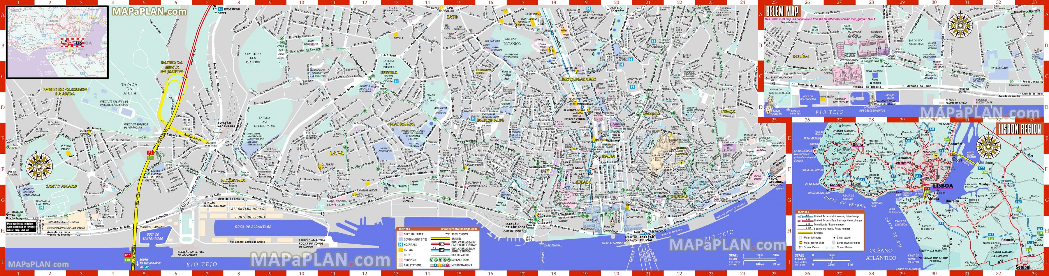
The Lisbon roads map shows all road network and highways of Lisbon. This roads map of Lisbon will allow you to find your routes through the roads and motorways of Lisbon in Portugal. The Lisbon roads map is downloadable in PDF, printable and free.
A large part of the well-maintained motorways system around Lisbon is toll roads as its shown in Lisbon roads map. Lisbon roads are narrow and old. Traffic drives on the right-hand side of the road and the national speed limit of Portugal is 90km/h. The toll roads costs from Lisbon to Sintra are around €1,50 euros.
If you go in the direction of Cascais and / or Sintra you can take the A5 (toll road) or the A37 as its mentioned in Lisbon roads map. If you have time to do a little tour then the N6 that merges with the N247 is the best way to go. It is the coastal road that runs along the beaches of Lisbon and Belém, via Cascais and Cabo da Roca to Sintra. Especially on the first stretch from Lisbon to Cascais, the N6 road is very narrow and traffic can be quite busy.
The region that saw the biggest increase in road deaths was the Algarve, jumping 30 percent to 41 in the past 12 months. This road deaths total is only one fewer than the Greater Lisbon Metropolitan Area, which has a population almost seven times greater than that of the Algarve (see Lisbon roads map).